

- お役立ち記事
- Basics of GPS/GNSS positioning and practical programming of positioning algorithms

その単価は妥当か。
AI が根拠付きで分析。
相見積の比較も発注も進捗管理も、ひとつの画面に。

Basics of GPS/GNSS positioning and practical programming of positioning algorithms

目次
Understanding GPS and GNSS
To begin exploring the fascinating world of positioning technologies, it’s crucial to understand what GPS and GNSS stand for.
GPS, or Global Positioning System, is a satellite-based navigation system that provides location and time information under any weather conditions.
It requires an unobstructed line of sight to four or more GPS satellites.
GNSS, on the other hand, stands for Global Navigation Satellite System.
While GPS is specific to the United States, GNSS is a general term that includes other satellite navigation systems.
These systems include Russia’s GLONASS, Europe’s Galileo, and China’s BeiDou.
Together, these systems provide a more robust and accurate positioning capability.
How Positioning Works
Positioning using GPS or GNSS is based on a principle known as trilateration.
This involves measuring the distances from a GPS receiver to at least four satellites.
Each satellite defines a sphere, and the receiver’s location is where these spheres intersect.
To determine these distances, the system uses the travel time of radio signals.
Since these signals travel at the speed of light, the receiver calculates how long they take to reach it from a satellite.
By knowing the time it took, the system can calculate the exact distance to each satellite.
The accuracy of this process depends on several factors including signal blockage, atmospheric conditions, and satellite geometry.
The more satellites a receiver can see, the more accurate the positioning.
Components of GPS/GNSS
A GPS or GNSS consists of three main components:
1. **Space Segment**: This includes the constellation of satellites orbiting Earth.
These satellites continuously transmit timing and positioning signals.
2. **Control Segment**: Ground stations that monitor and manage the satellite signals at various locations around the world.
They ensure the satellites remain in the correct orbit and make the necessary adjustments to maintain accuracy.
3. **User Segment**: This involves GPS receivers, which can be found in devices such as smartphones, cars, and handheld navigation systems.
They receive signals from satellites and use them to calculate the user’s location.
Programming Positioning Algorithms
Understanding how to program positioning algorithms can leverage the data from GPS/GNSS to create various applications.
Setting Up the Environment
To start programming positioning algorithms, you’ll need a development environment with support for languages like Python or C++, which offer libraries for handling GPS data.
Python, for example, has libraries like Pyproj and Geopy that simplify the process of working with geospatial data.
Setting up these libraries in a Python environment is a straightforward process and can be easily done using package management tools like pip.
Implementing a Basic GPS Algorithm
A basic GPS positioning algorithm involves:
1. **Reading GPS Data**: Most GPS modules output data in NMEA format containing a wealth of information such as latitude, longitude, altitude, and time.
You can parse this data using regular expressions or libraries like pynmea2 in Python.
2. **Handling Coordinate Transformation**: Sometimes, it is necessary to convert coordinates between different formats or datums.
Libraries like Pyproj are useful for transforming coordinates from one reference frame to another.
3. **Calculating Distances and Directions**: Use mathematical formulas such as the Haversine formula to calculate distances between two points on the Earth’s surface.
This is particularly useful for navigation and routing applications.
Advanced Positioning Techniques
To achieve higher accuracy, you can implement advanced positioning techniques like Differential GPS (DGPS) and Real-Time Kinematic (RTK) systems.
– **Differential GPS (DGPS)** uses a network of fixed ground-based reference stations to broadcast differences between the positions indicated by the satellites and the known fixed positions.
This improves accuracy by correcting errors from satellite signals.
– **Real-Time Kinematic (RTK) Systems** provide greater precision than standard GPS.
They use a fixed base station and a rover receiver to process satellite signals in real time, offering centimeter-level accuracy.
Applications of GPS/GNSS Technologies
GPS and GNSS technologies have revolutionized many industries.
1. **Navigation**: One of the most common applications is vehicular navigation.
GPS is used in cars, ships, and aircraft for route determination and real-time tracking.
2. **Surveying**: Land surveyors use GNSS for precise measurements of land boundaries and construction projects.
3. **Agriculture**: Precision farming employs GNSS for optimizing the use of resources, improving crop yields, and automating machinery.
4. **Trekking and Outdoor Adventures**: GPS devices assist hikers and explorers in navigating difficult terrains and recording their paths.
5. **Search and Rescue**: Emergency services utilize GNSS for locating and reaching those in need within remote areas.
Each application exhibits the transformative impact of positioning technologies, emphasizing the need for further development and integration of these systems into everyday life.
Conclusion
Understanding the basics of GPS and GNSS positioning technologies is essential for developing practical applications across various fields.
Whether you’re developing navigation software or improving farming efficiency, these systems provide the cornerstone technology that can bring innovative solutions to practical challenges.
With advancements in programming and algorithm development, the potential uses of GPS and GNSS are virtually limitless.
この記事の理解を深める
無料ホワイトペーパーをプレゼント
製造業の現場で使える実務資料(PDF)を無料でお届けします。"こんな資料が届きます" ↓ 下のボタンからどうぞ。
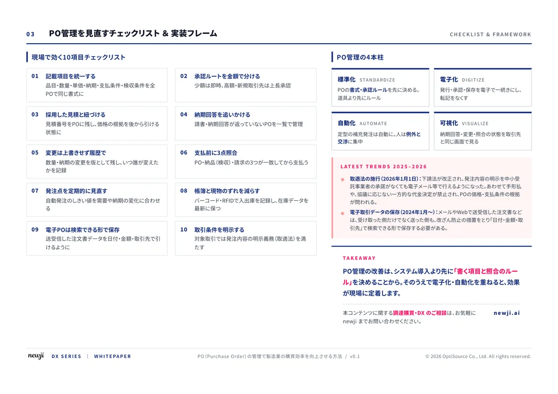
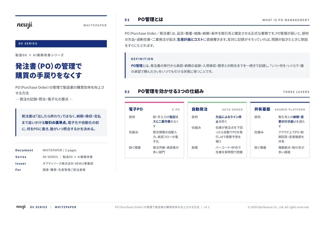
FREE DOCUMENT — サービス資料(PDF・無料)
製造業の見積・受発注クラウド
「Newji one」とは
Newji one は、製造業の調達・受発注に特化したクラウド/AIエージェント。見積依頼・発注書作成・進捗管理・承認をひとつの画面に集約し、AIが比較と異常検知を担当。最後の「GO」だけ人が押す仕組みです。
▶ 製造業の見積・受発注クラウド「Newji one」を、資料で見る(PDF・無料)
- 見積〜発注〜納期を一元管理。催促・転記のムダをゼロに
- AIが相見積もり比較と異常検知。あなたは判断だけに集中
- 取引先は「招待」で完全無料。自社コストだけで取引先ごとデジタル化
※ 取引先から招待された企業様は完全無料でご利用いただけます


 NEWJI総研
 OEM/ODM 生産委託
 AI/DX支援
 見積・発注クラウド Newji one
受発注が増えるほど、入力・確認・催促が重くなる。
受発注管理を“仕組み化“して、ミスと工数を削減しませんか。
見積・発注・納期まで一元管理できます。