

- お役立ち記事
- Basics of GPS GNSS QZSS and application to system development

その単価は妥当か。
AI が根拠付きで分析。
相見積の比較も発注も進捗管理も、ひとつの画面に。

Basics of GPS GNSS QZSS and application to system development

目次
What is GPS?
The Global Positioning System, or GPS, is a satellite-based navigation system that enables a GPS receiver to determine its exact location on Earth.
Developed by the United States Department of Defense, it was originally intended for military purposes but is now widely available for civilian use.
The system is made up of a network of around 24 satellites orbiting the Earth.
GPS works by sending signals from these satellites to a GPS receiver, which then calculates its position based on the time it takes for the signals to arrive.
Understanding GNSS
Global Navigation Satellite System (GNSS) is a general term that encompasses all satellite navigation systems.
While GPS is a specific system developed by the U.S., other countries have developed their systems.
These include Russia’s GLONASS, the European Union’s Galileo, and China’s BeiDou.
GNSS receivers can use signals from any available satellite navigation system.
This increases accuracy and reliability as more satellite signals become available for position determination.
In this way, GNSS offers improved performance over using a single system like GPS alone.
Introducing QZSS
The Quasi-Zenith Satellite System (QZSS) is a regional satellite navigation system developed by Japan.
It is designed to enhance the function of GPS in the Asia-Oceania region, providing more accurate positioning data.
QZSS uses satellites that travel in an orbit which ensures they are always high in the sky over Japan.
This helps to minimize urban canyon effects where tall buildings and natural landscapes block satellite signals.
In Japan, QZSS is often referred to as “Japanese GPS”.
Applications in System Development
The integration of GPS, GNSS, and QZSS into various technologies has revolutionized the way systems are developed across numerous sectors.
From agriculture to transportation, these satellite navigation systems enhance accuracy, efficiency, and safety.
Agricultural Advancements
In agriculture, GPS technology is used for precision farming.
It helps farmers plan their work with precision, reducing waste and improving yield.
By using GPS-enabled devices, farmers can guide tractors and equipment more accurately.
This is beneficial for planting, fertilizing, and harvesting, leading to increased productivity and reduced costs.
Improving Transportation
Transportation sectors, particularly logistics and automotive, utilize GPS and GNSS technologies for navigation and tracking.
These systems provide real-time location data, which is crucial for route optimization and fleet management.
In-vehicle navigation systems help drivers reach their destinations efficiently and safely.
Enhancing Geolocation Services
For telecommunication and mobile devices, GNSS enhances geolocation applications, allowing users to pinpoint their location with greater accuracy.
This is essential for services such as navigation apps, emergency services, and even for social media check-ins.
With GNSS integration, users in dense urban areas benefit from improved signal reception and precision.
Disaster Management and Response
In disaster management, the timely and accurate positioning provided by these satellite systems aids in planning and executing emergency response operations.
This can be crucial for locating affected areas, deploying resources efficiently, and coordinating rescue efforts.
GNSS technology helps emergency teams access areas that may be difficult to navigate otherwise.
Scientific and Environmental Research
Research and environmental monitoring are also significant benefactors of GNSS and GPS technologies.
Scientists use satellite navigation data to track climate change, and monitor tectonic movements, and sea levels.
This technology also helps in wildlife tracking and conservation efforts by providing accurate location data.
Developing GNSS-Based Systems
Developing systems that leverage GPS, GNSS, and QZSS requires careful planning and a clear understanding of the technologies involved.
Engineers and developers need to consider factors such as signal availability, accuracy requirements, and the intended application.
User Requirements
Understanding the user requirements is crucial.
The system should be tailored to meet the specific needs of its users.
For example, a navigation system for aviation will have different needs compared to a mobile app for hikers.
Signal Processing
Signal processing is a vital part of system development.
It involves decoding the signals received from satellites and converting them into useful data.
Advanced algorithms are used to enhance signal accuracy and reliability, especially in challenging environments.
Integration with Other Technologies
Integration with other technologies can enhance the capabilities of a GNSS-based system.
This can include integrating with sensors, communication networks, or databases.
Such integration often results in a more robust and versatile system.
The Future of Satellite Navigation Systems
The future of GNSS and related technologies looks promising, with continual advancements expected to enhance accuracy, reliability, and availability.
Emerging technologies like autonomous vehicles and drones are heavily reliant on these systems.
Furthermore, technological advancements in satellite systems such as the introduction of new satellites, improved algorithms, and integration with other technologies could reshape various industries.
As these systems evolve, developers and engineers will have more opportunities to create innovative solutions that leverage enhanced satellite navigation capabilities.
この記事の理解を深める
無料ホワイトペーパーをプレゼント
製造業の現場で使える実務資料(PDF)を無料でお届けします。"こんな資料が届きます" ↓ 下のボタンからどうぞ。
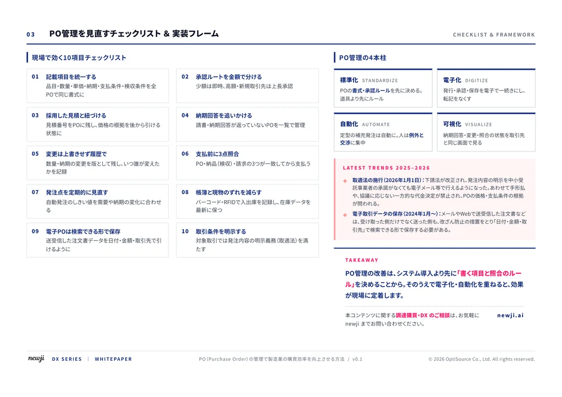
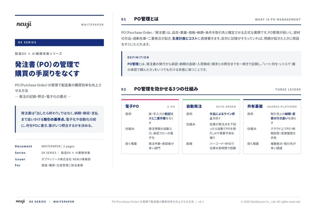
FREE DOCUMENT — サービス資料(PDF・無料)
製造業の見積・受発注クラウド
「Newji one」とは
Newji one は、製造業の調達・受発注に特化したクラウド/AIエージェント。見積依頼・発注書作成・進捗管理・承認をひとつの画面に集約し、AIが比較と異常検知を担当。最後の「GO」だけ人が押す仕組みです。
▶ 製造業の見積・受発注クラウド「Newji one」を、資料で見る(PDF・無料)
- 見積〜発注〜納期を一元管理。催促・転記のムダをゼロに
- AIが相見積もり比較と異常検知。あなたは判断だけに集中
- 取引先は「招待」で完全無料。自社コストだけで取引先ごとデジタル化
※ 取引先から招待された企業様は完全無料でご利用いただけます


 NEWJI総研
 OEM/ODM 生産委託
 AI/DX支援
 見積・発注クラウド Newji one
受発注が増えるほど、入力・確認・催促が重くなる。
受発注管理を“仕組み化“して、ミスと工数を削減しませんか。
見積・発注・納期まで一元管理できます。