

- お役立ち記事
- Latest spatial modeling technology and its applications using sensor data

その単価は妥当か。
AI が根拠付きで分析。
相見積の比較も発注も進捗管理も、ひとつの画面に。

Latest spatial modeling technology and its applications using sensor data

Spatial modeling technology has seen significant advancements in recent years, particularly in how it utilizes sensor data to make predictive analyses and optimizations across various industries.
Understanding these technologies and their applications can provide valuable insights into modern advancements and future possibilities.
目次
What is Spatial Modeling?
Spatial modeling involves creating mathematical representations of the arrangement and relationships of objects in space.
This technique helps us understand and simulate phenomena that occur over geographic areas.
By analyzing spatial patterns and connections, we can make informed decisions and predictions about environmental, social, and economic issues.
The Role of Sensor Data in Spatial Modeling
Sensors play a pivotal role in collecting real-time data across diverse environments.
These sensors might include GPS systems, environmental sensors, cameras, and mobile devices that collect data such as temperature, humidity, movement, or location.
This data is then used to feed spatial models to better simulate real-world phenomena.
Types of Sensors Used in Spatial Modeling
To understand the applications of spatial modeling, it’s essential to know the types of sensors that are commonly used.
GPS Sensors
Global Positioning System (GPS) sensors provide critical geolocation data for tracking the movement of objects over time and space.
They are integral to various applications, including navigation, fleet management, and mapping services.
Environmental Sensors
These sensors monitor physical conditions of the environment such as temperature, humidity, air quality, and pollution levels.
They are used in agriculture, urban planning, and climate monitoring to track changes and predict outcomes.
Imaging Sensors
Imaging sensors, like cameras and satellites, capture visual data that can be processed for pattern recognition, object detection, and landscape analysis.
They are vital in remote sensing and geographic information system (GIS) applications.
Mobile and IoT Sensors
Mobile devices equipped with accelerometers, gyroscopes, and other sensors provide nuanced movement and orientation data.
The Internet of Things (IoT) extends the network of sensors, offering enhanced data collection for smart cities and connected devices.
Applications of Spatial Modeling Technology
Spatial modeling technology, fueled by sensor data, offers numerous applications across various sectors.
Urban Planning and Development
One of the primary applications of spatial modeling is in urban planning.
By analyzing spatial data, planners can design more efficient transportation networks, optimize land use, and resolve congestion issues.
It enables the creation of sustainable and resilient cities by predicting urban growth patterns and assessing the impact of infrastructure projects.
Agriculture and Land Management
Spatial modeling in agriculture helps farmers optimize crop yields by analyzing soil properties, moisture levels, and weather patterns.
It assists in precision farming, where resources like water and fertilizers are used efficiently, reducing waste and environmental impact.
In land management, spatial models help in forest monitoring, conservation planning, and biodiversity assessments.
Disaster Management
Utilizing real-time data and spatial models, emergency response teams can enhance disaster preparedness and response strategies.
Predicting natural disasters like floods, hurricanes, and earthquakes becomes more accurate, allowing for timely evacuations and resource allocation.
Spatial modeling also aids in post-disaster assessments for recovery planning.
Environmental Monitoring
Spatial technology aids in tracking and mitigating climate change effects by analyzing data on greenhouse gas emissions, deforestation, and habitat changes.
It supports environmental conservation efforts by providing insights on ecosystem health and changes over time.
Health and Epidemiology
Spatial models help identify disease spread patterns and at-risk populations.
This information is crucial for implementing public health interventions and monitoring disease outbreaks.
Sensor data allows for accurate mapping of health-related issues across different regions.
The Future of Spatial Modeling Technology
The future of spatial modeling looks promising with the continuous evolution of technology and data collection methods.
Integration with AI and Machine Learning
Incorporating artificial intelligence (AI) and machine learning (ML) into spatial modeling enhances predictive capabilities.
These technologies can identify complex patterns and correlations in large datasets, leading to more accurate and insightful predictions.
Real-Time Data Processing
As technology evolves, the ability to process data in real-time becomes more feasible, leading to immediate applications of spatial models in dynamic environments.
This capability is especially important in fields requiring quick decision-making, such as disaster response and traffic management.
Increased Accessibility and Collaboration
With advancements in cloud computing and open-source platforms, spatial modeling tools are becoming more accessible to researchers, policymakers, and the general public.
This democratization of technology fosters greater collaboration and innovation across sectors.
Spatial modeling technology, driven by sensor data, continues to revolutionize how we interact with the world.
Its expanding applications promise more informed decision-making and a deeper understanding of the spatial relationships that shape our lives.
As technology advances, the potential for spatial modeling across disciplines will only grow, offering solutions and insights for the challenges of tomorrow.
この記事の理解を深める
無料ホワイトペーパーをプレゼント
製造業の現場で使える実務資料(PDF)を無料でお届けします。"こんな資料が届きます" ↓ 下のボタンからどうぞ。
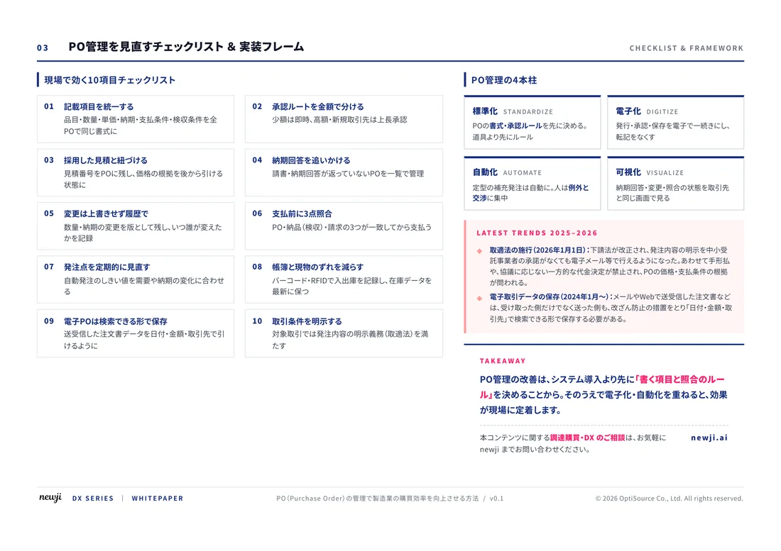
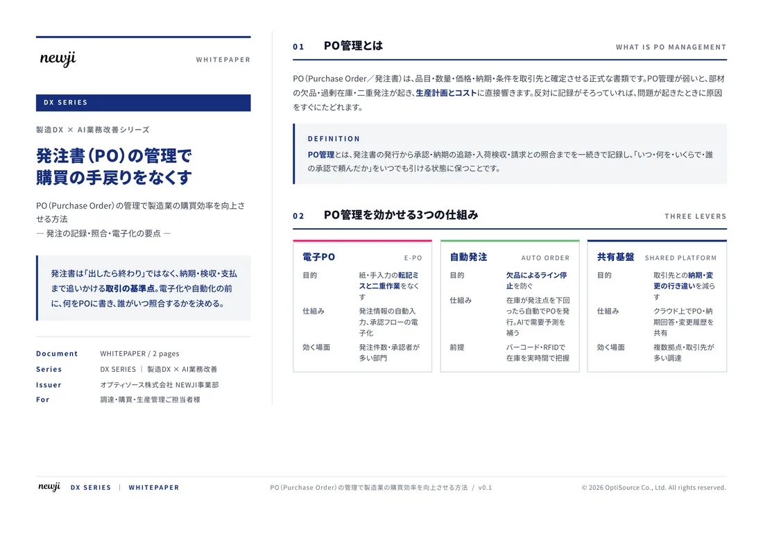
FREE DOCUMENT — サービス資料(PDF・無料)
製造業の見積・受発注クラウド
「Newji one」とは
Newji one は、製造業の調達・受発注に特化したクラウド/AIエージェント。見積依頼・発注書作成・進捗管理・承認をひとつの画面に集約し、AIが比較と異常検知を担当。最後の「GO」だけ人が押す仕組みです。
▶ 製造業の見積・受発注クラウド「Newji one」を、資料で見る(PDF・無料)
- 見積〜発注〜納期を一元管理。催促・転記のムダをゼロに
- AIが相見積もり比較と異常検知。あなたは判断だけに集中
- 取引先は「招待」で完全無料。自社コストだけで取引先ごとデジタル化
※ 取引先から招待された企業様は完全無料でご利用いただけます

 NEWJI総研
 OEM/ODM 生産委託
 AI/DX支援
 見積・発注クラウド Newji one
受発注が増えるほど、入力・確認・催促が重くなる。
受発注管理を“仕組み化“して、ミスと工数を削減しませんか。
見積・発注・納期まで一元管理できます。