

- お役立ち記事
- On-site utilization technology of 3D measurement using drones and key points of data processing

その単価は妥当か。
AI が根拠付きで分析。
相見積の比較も発注も進捗管理も、ひとつの画面に。

On-site utilization technology of 3D measurement using drones and key points of data processing

目次
Introduction to 3D Measurement with Drones
In recent years, the use of drones for 3D measurement has become a transformative technology in various industries.
From construction and agriculture to environmental monitoring, drones offer a new dimension of precision and efficiency.
Understanding the key points of data processing in these applications is vital for optimizing their utility.
How Drones are Used for 3D Measurement
Drones equipped with advanced sensors and cameras can capture high-resolution images and data from above.
These aerial perspectives provide an innovative way to create 3D models of landscapes, structures, and various sites.
The collected data can then be processed using photogrammetry software to construct detailed three-dimensional maps and models.
Advantages of Drone-Based 3D Measurement
Drone technology provides several advantages over traditional survey methods.
Firstly, drones can rapidly cover vast areas with precision, reducing the time and labor required for surveys.
They can also access hard-to-reach areas that might be dangerous or impossible to survey by human crews.
Moreover, the accuracy of data collected by drones has significantly improved with advancements in GPS, stabilization technology, and image resolution.
This results in highly precise 3D maps and measurements, which are invaluable in planning and decision-making processes.
Industries Benefiting from Drone Technology
The capability for 3D measurement using drones is particularly beneficial in industries such as construction, mining, agriculture, and environmental management.
Construction and Infrastructure
In construction, drones provide accurate site surveys and monitoring.
They facilitate progress tracking, volume measurement, and structural inspection.
This helps in maintaining timelines, securing worker safety, and ensuring project quality.
Mining and Resource Management
In the mining sector, drones can survey large areas effectively, making it easier to measure stockpiles, plan operations, and monitor environmental impacts without disrupting workflows.
Agriculture
For agriculture, drones are used to create detailed 3D maps of fields, which aid in efficient crop management.
These maps help in understanding field variability, assessing crop health, and optimizing irrigation.
Key Points of 3D Data Processing
The effectiveness of drone-based 3D measurement largely depends on the quality of data processing.
Understanding these key points is essential for maximizing the utility of 3D models.
Data Collection
The initial step is data collection where the quality of images and sensor readings is crucial.
Pilots must ensure that the drone’s flight path covers all necessary angles and areas with sufficient overlap to facilitate accurate 3D reconstruction.
Photogrammetry and 3D Modeling
Advanced photogrammetry software processes the collected data to create 3D models.
This involves stitching together multiple images and correcting for any distortions based on the drone’s sensor data and camera angles.
The software uses algorithms to align and translate the images into a precise spatial representation.
Data Validation and Accuracy Checking
Ensuring data accuracy is critical.
Comparison with ground control points (GCPs) provides a benchmark for accuracy.
Matching the model against known measurements in the real world helps validate the data.
Integration with Geographic Information Systems (GIS)
Integrating 3D models into GIS allows for enhanced analysis and visualization.
GIS platforms can manage, analyze, and display geographically referenced information, which is useful for further spatial planning and decision-making.
Challenges and Considerations
Despite its advantages, using drones for 3D measurement comes with certain challenges.
Operators must be aware of regulatory requirements and fly within legal parameters related to height, privacy, and no-fly zones.
The weather is also a significant factor since conditions such as strong winds, rain, or heavy fog can affect drone stability and data quality.
Ensuring appropriate data storage and processing capacity is important, given the large volumes of data collected.
Efficient hardware and software are necessary to handle and analyze this data efficiently.
Future Prospects
As drone technology continues to evolve, its applications for 3D measurement and data processing will likely expand.
Improvements in artificial intelligence and machine learning are expected to enhance data processing capabilities, paving the way for even more precise modeling and analytics.
The integration of real-time processing and cloud computing will also offer new dimensions of efficiency and collaboration, making drone-based 3D measurement an indispensable tool across various sectors.
Conclusion
3D measurement using drones represents a significant advancement in data collection and processing.
It offers unparalleled benefits in speed, safety, and accuracy across diverse industries.
By understanding and mastering the key points of data processing, users can leverage these technologies to enhance productivity and decision-making, heralding a new era of precision and insight.
この記事の理解を深める
無料ホワイトペーパーをプレゼント
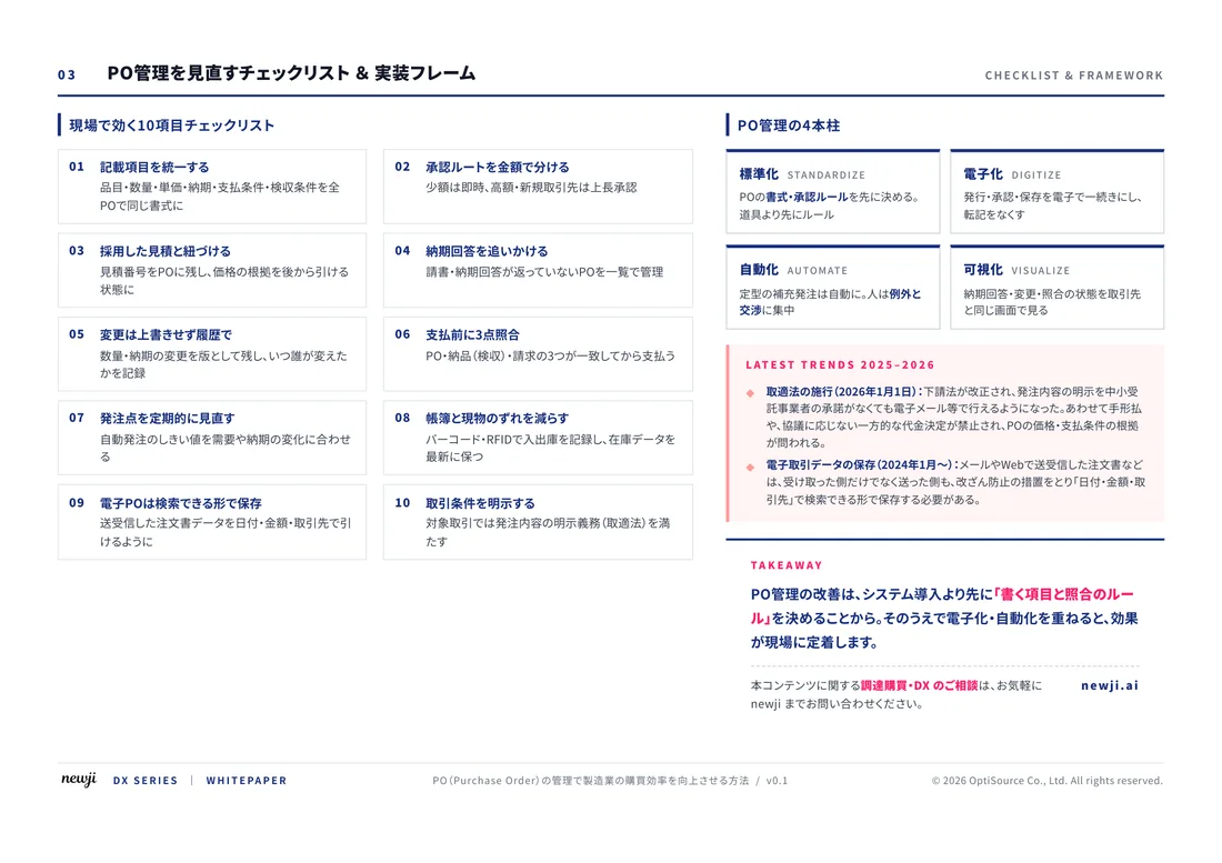
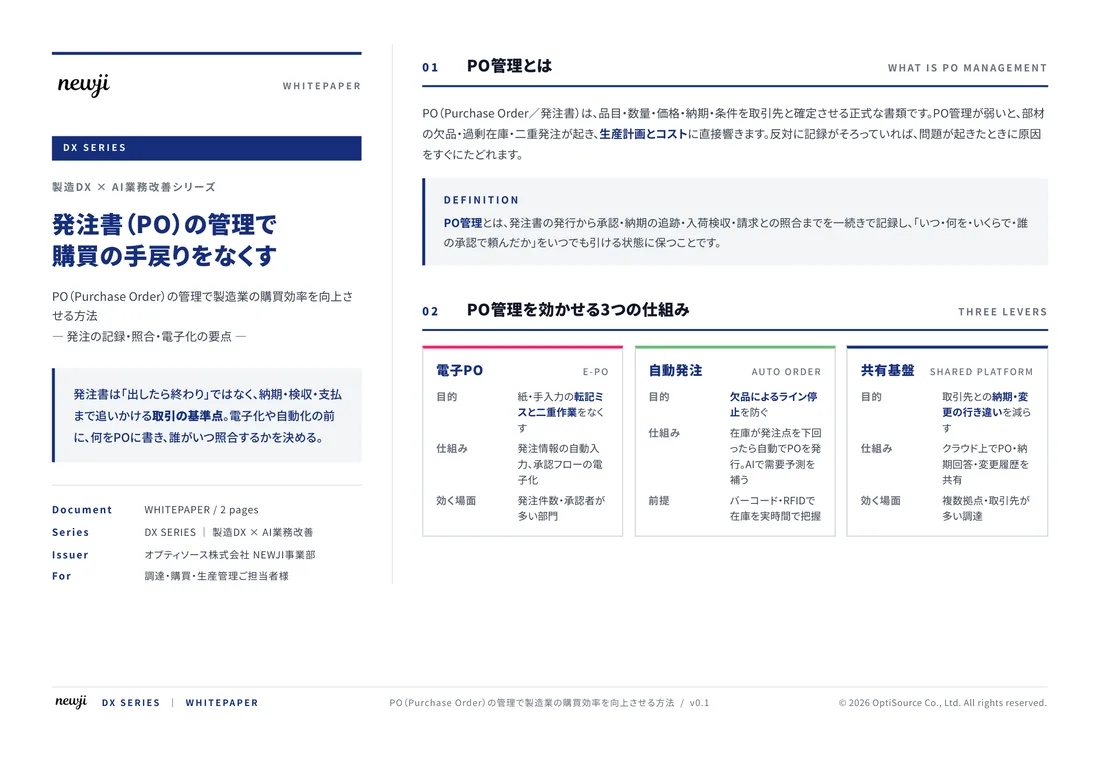
製造業の現場で使える実務資料(PDF)を無料でお届けします。"こんな資料が届きます" ↓ 下のボタンからどうぞ。
FREE DOCUMENT — サービス資料(PDF・無料)
製造業の見積・受発注クラウド
「Newji one」とは
Newji one は、製造業の調達・受発注に特化したクラウド/AIエージェント。見積依頼・発注書作成・進捗管理・承認をひとつの画面に集約し、AIが比較と異常検知を担当。最後の「GO」だけ人が押す仕組みです。
▶ 製造業の見積・受発注クラウド「Newji one」を、資料で見る(PDF・無料)
- 見積〜発注〜納期を一元管理。催促・転記のムダをゼロに
- AIが相見積もり比較と異常検知。あなたは判断だけに集中
- 取引先は「招待」で完全無料。自社コストだけで取引先ごとデジタル化
※ 取引先から招待された企業様は完全無料でご利用いただけます

 NEWJI総研
 OEM/ODM 生産委託
 AI/DX支援
 見積・発注クラウド Newji one
受発注が増えるほど、入力・確認・催促が重くなる。
受発注管理を“仕組み化“して、ミスと工数を削減しませんか。
見積・発注・納期まで一元管理できます。